WTTW did a program once about IL 1. They drove from downstate to
 I shot out of the city on
It felt good to be back a-wheel.
I didn’t see Archie and the gang in Riverdale, but I got caught by a freight train for 15 minutes. Competing varieties of gospel music blared from the open windows of the queued cars.
My route would take me near Glenwood and
“But what if it was just around the corner?” I thought, making a sudden left on
I asked directions of the gents manning the recycling drop off center, where people motor over their trash to feel like they’re “environmentalists.” The cemetery was only a half mile away, but on the other side of the forest preserve, requiring a 4 mile loop north. No problem. I followed their instructions, but could not recall the final street in the series and guessed wrong, ending up south of where I started on
 Heading further east to take another pass, I turned north on
I asked a municipal worker near Jurgensen Woods. He could cite no street names, just navigation via landmark: the traffic light, the tracks, the bridge. I disregarded the road closed signs on Thorn Creek and the rocks in the exposed roadbed grew from fist size to head size. Eventually I was ‘out of the woods’ and into
 “Worlds champion bicycle racer who came up the hard way without hatred in his heart, an honest, courageous, and God-fearing, clean-living, gentlemanly athlete. A credit to his race who always gave out his best. Gone but not forgotten.”
The plaque was installed in 1948 by a group of retired racers and the Schwinn Company. They also exhumed and relocated his remains from a pauper’s grave.
The excursion had added 12 miles and killed over an hour and a half. I tired of the traffic on Halsted, so I took the back-roads to check out the Thorn Creek South Trail. The pavement went from bad to worse to non existent so I bailed and jumped on the CBF recommended route southbound. Soon the smell of burning leaves marked my exit from civilization.
 It was about 11am and I’d done 50 miles, but I should have done 70 with the tailwind I was enjoying. Now off the CBF map, I checked out the IDOT bike map's recommendation, Western Av., which was flanked by cornfields. The previous day Daisy and I had accompanied my friend Ruth Welte for a few miles as she walked the length of the city on Western Av. for an upcoming feature in Time Out Chicago. It will be interesting to see if she encountered any agriculture.
I backtracked to
 His name was John, of
John accompanied me for a while, guiding us to the better roads and even being sport enough jog over to Momence, where he used to play country music at the Budweiser Inn. I went looking for provisions while he soaked his feet a bit in the Kankakee River
From
Regardless, I have sworn to eat only quality vittles on these trips from now on, so I set about finding a proper eatery. Two good looking diners downtown were closed. I just couldn’t abide the hot dog stand that served no fries. The DQ served only iced cream. Pizza by the slice, closed. Another fantastic looking home cooking joint, closed. Another location of the fri-less hotdog franchise.
I was getting dizzy, tired and crabby when I happened upon JR’s Chicken. The girl was mildly rude, the sides small and I wished I’d noticed the buffet before I’d ordered carry out, but the fried chicken was truly stellar.
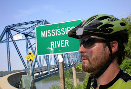
 Fully sated I began trekking northwest along the river, to my next destination:
Reviewing my trip, I see that there is also a KRSP just across the
Next up was my attempt to connect with the Wauponsee Glacial Trail. The IDOT map showed it as ‘proposed’ reaching the
Midewin is the former site of the Joliet Arsenal, 19,000 acres of land fenced off during WW II, the land to keep the general public away from the production of TNT. To give you an idea, an explosion in 1942 killed 40 workers and broke out windows in downtown
 I arrived at the park headquarters only to find it closed, but with enough employee presence as to prevent my typical fence hopping. I backtracked to
 To be clear, there isn’t much prairie at the Tallgrass Prairie. Much of it is leased as farm land, there’s some industrial development, a landfill, numerous small cemeteries and the munitions plants and bunkers. None the less it is an amazing place and I took numerous photos of the aging structures and weed choked roads during my unfortunately brief ride across it.
 It was now about 8:45pm, sunset and I had 145 miles on my legs. It was time to get serious. I wrote out a detailed route, donned the reflective vest, fired up my five lights and hit the unsigned road.
Some months back my friend Shawn Greene gave me a few Songs: Ohia recordings. It took a few listenings before I got into them, but I had the song “The Farewell Transmission” repeating in my mind all day, its lyrics becoming increasingly personal:
The real truth about it is
my kind of life's no better off
If I've got the maps or if I'm lost…
I didn’t start out from where I thought, so I guess I wasn’t on my route to begin with. No matter, I remained on a northeast course, left-right turning until I found my streets. Road construction forced me to quickly abandon the route (I’d learned to heed the road closed signs.) Fireworks shot up to the left and right, like coded signals between parties miles apart.
I took a short spin on the Old Plank Road Trail, which I had intended to follow in its entirety before overextending my mileage forced me on a more direct course. I’ve done portions of the OPRT in the past; it’s wide, paved the full length and the cross streets signed. It passes through some nice wetlands and suffers only the occasional road crossing. It was nice to get away from the numerous oncoming idiots who felt the need to illuminate me with their high-beams.
The real truth about it is
there ain't no end to the desert I'll cross
I've really known that all along…
I exited the trail and rolled up on a series of
My good fortune continued finding the next street in our series,
Mama
here comes midnight
with the dead moon in its jaws..
171 is the most direct route from the Joliet area, but I opted to pass few nasty stretches of lousy pavement and bad sightlines. The real obstacle, however, is the interchange with the 294 toll-way, Where several lanes of 70 mph traffic cross each other.
I’ve been on some pretty hairy roads in my time, even riding illegally on the interstate, but this exchange is hands down thee most dangerous place I have ever ridden a bicycle.
Fortunately there exists an alternative, albeit a somewhat tricky trespass: Jedle's Pass.
1) Get yourself onto the I&M Canal Trail near Willow Springs.
2) Follow it north until the turn around at the overpass of La Grange Rd. (US 45)
3) Cross the train tracks to your right (northeast) and cut through the trailer park.
4) Ride northeast on Testa Dr., which is a loop through the trailer park.
5) Exit the park 79th St. which runs parallel to 171/Archer.

202 miles for the day, 19 hours out, 15 in the saddle.
T.C.
See all the Ride Photos: http://www.flickr.com/photos/tcorourke/sets/72157600783052907/
See the general route here

4 comments:
I'm happy to see that you have not stopped your training. The large gap in your blog had me worried.
Keep up the good work.
Nice interludes of lyrics. Good job, T.C. Keep the engines warm and ready. Paris is rising over the ocean and arriving soon.
Hey TC, the two mountain bike guys you met at JAAP are friends of mine:
http://www.bradpogatetz.com
http://www.chucksphotospot.com
Great work with the blog thing you got going here, good luck with the riding and all of that, etc...
-Noah
I thought Midewin was supposed to be the largest prairie restoration project in the country.
Post a Comment